Good day!
Almost every one of us has found ourselves in a situation where you wander into an unfamiliar part of the city and try to find the right address. Now, of course, technology has stepped forward and a regular smartphone allows you to navigate the terrain great...
However, far from everywhere and not everything is drawn on Google and Yandex maps. Not so long ago, I was in a new part of my city, and, as it turned out, some streets of this area are simply not shown on the map. How can you tell another person where you are and how to find you? 
Actually, this small note is devoted to coordinates and search specific point on the map using map services from Yandex and Google. So...
How to determine your coordinates and how to find an address by coordinates
I'll start with Google maps, the official site :
For exact definition your coordinates - click on the "Location determination" button, usually a small window immediately pops up in the browser asking whether to allow access (select "I allow").

Important! By the way, in some cases, different services may show you in " different places". Therefore, double-check your coordinates on 2 maps at once.
If the street is long, and there are no house numbers (or, Google maps do not show houses in this territory at all) - then left-click on the point next to the one determined by Google - a small tab should pop up below, in which your coordinates!
Coordinates represent out of two numbers. For example, on the screen below, these are: 54.989192 and 73.319559
Knowing these numbers, you can transfer your location to anyone (even if he does not use Google maps, which is very convenient).

To find the desired point in Google by coordinates, just open the maps and enter these two numbers in the search box (upper left): after 1-2 seconds. a red flag will light up on the maps, indicating the desired point.

Note:
- coordinates must be specified through a dot, not a comma (correct: 54.989192 73.319559; incorrect: 54.989192 and 73.319559);
- indicate the coordinates in the order in which their map gives you: i.e. first latitude, then longitude (if you violate the order, you will get the wrong point at all, perhaps even 1000 km further than the desired one ...);
- coordinates can be specified in degrees and minutes (example: 51°54" 73°31").
Yandex maps
By and large, with Yandex-maps, the principle of operation is similar. It is worth noting that if one service does not determine the address, try using another one. Sometimes, if a street or area is not drawn in Google maps, then in Yandex, on the contrary, it is displayed quite fully, all streets are signed, and you can easily find out where to go and what to do.
Yandex Maps also has a special. a tool that allows you to find out your location online (on the right, click on the arrow in the white circle, see the screen below).

To determine the coordinates - just click on the necessary points on the map - a small window will pop up with addresses and two numbers - that's what they are.

You can insert both a specific address and coordinates into the search string (do not forget that they must be set correctly: do not confuse the sequence, specify through a dot, not a comma!).

Addition!
I have another article of a similar nature on my blog - about determining distances between cities, choosing the best road and estimating travel time. It will be useful to everyone who is going to go to another city, I recommend:
Additions are welcome...
The geographic coordinate system is necessary in order to determine the location of an object on the surface of the Earth with great accuracy. As you know, this system consists of geographic latitude and longitude. The first element of this system is the angle between the local zenith (noon) and the plane of the equator, ranging from 0 to 90 degrees west or east of the equatorial boundary. Longitude is the angle formed by two planes: the meridian passing through a given point in the area and the Greenwich meridian, i.e. zero point. From the latter, the longitude begins, which is from 0 to 180 degrees east and west (east and west longitude). Knowing how to navigate the terrain using latitude and longitude will help you communicate your exact coordinates in case of an emergency, when you find yourself in an unfamiliar place that is not marked on the map, or get lost in the forest. Learn more about how you can determine the latitude and longitude of your location.
Clock to determine location by latitude and longitude
How to determine a place by latitude and longitude

The determination of local geographic longitude is carried out using conventional clocks. To do this, you need to set on them the exact time of the location in this moment. Then you should determine the time of the local noon, this will help the time-tested method: you need to find a meter or one and a half meter stick, stick it vertically into the ground. The length of the drop shadow line will show the time intervals that need to be detected. The moment when the shadow will be the shortest is the local zenith, i.e. the gnomon shows exactly 12 noon, while the direction of the shadow is from south to north.
At this time, you need to note the time on the clock - this will be the indication of Greenwich Mean Time. From this value, you need to subtract the indicator, which is taken from the time equation table. This correction arises due to the variability of the angular velocity of motion and the dependence on the season. Given this correction, the average value of Greenwich time is reduced to true solar. The resulting difference between this solar time (i.e. 12 hours) and Greenwich Mean Time, taking into account the correction, must be converted into a degree value. To do this, you need to know that in one hour the Earth rotates 15 degrees (if you divide 360 degrees by 24 hours) of longitude, or 1 degree in four minutes. If noon in a given area comes earlier than Greenwich Mean Time, indicate east longitude in your calculations, if later, then west. The closer the coordinates of the desired area to the polar regions, the more accurate the longitude measurements will be.

The field of how the value of longitude is found, you can begin to determine the value of the latitude of a particular area. First you need to determine the duration of the daytime, which begins at sunrise and ends at sunset. Next, you need to draw up a nomogram, i.e. determination of latitude: on the left side the value of the daylight hours is indicated, on the right - the date. If you combine these values, you can determine the intersection of the geographic latitude with the middle part. The location found will indicate the local latitude. When determining latitude relative to the southern hemisphere, you must add 6 months to the required date. The second way is to find the latitude using a conventional protractor: for this, a plumb line (thread with a weight) is fixed in the center of this tool, and its base is pointed at the North Star. The angle formed by the plumb line and the base of the protractor must be reduced by 90 degrees, i.e. subtract this value from its value. The value of this angle shows the height of the North Star, i.e. the height of the pole above the horizon. Since the geographic latitude is equal to the value of the pole above the horizon of a particular place, this value will indicate its degree.
Geographical coordinates determine the position of a point on the earth's surface. Geographic coordinates are based on the principle of spherical and consist of latitude and longitude.

Latitude— the angle between the local direction of the zenith and the plane of the equator, measured from 0° to 90° on both sides of the equator. The geographical latitude of points lying in the northern hemisphere (northern latitude) is considered to be positive, the latitude of points in the southern hemisphere is negative. It is customary to speak of latitudes close to the poles as high, and about those close to the equator - as about low.
Longitude- the angle between the plane of the meridian passing through the given point, and the plane of the initial zero meridian, from which the longitude is counted. Longitudes from 0° to 180° east of the prime meridian are called east, to the west - west. Eastern longitudes are considered positive, western longitudes negative.
Format of recording geographic coordinates
Geographic coordinates of a single point can be expressed in different formats. Depending on whether minutes and seconds are represented as values from 0 to 60 or from 0 to 100 (decimal).
The coordinate format is usually written in the following way: DD- degrees, MM- minutes, SS- seconds, if minutes and seconds are represented as decimal fractions, then simply write DD.DDDD. For example:
- DD MM SS: 50° 40" 45"" E, 40 50" 30"" N - degrees, minutes, seconds
- DD MM.MM: 50° 40.75" E, 40 50.5" N - degrees, decimal minutes
- DD.DDDD: 50.67916 E, 40.841666 N - decimal degrees
Why do you need to know the coordinates of your house
 Often, houses in holiday villages and many villages do not have a clear navigation consisting of signs with street names and house numbers, or even houses with signs with numbers can be scattered throughout the village in a random order (historically formed as the village was built up). There are times when everything is fine with navigation in a village, but not all car GPS navigators have such a house or street. Residents of such houses have to explain for a long time and, as a rule, intricately how to get to them using different landmarks. In this case, it is easier to give the coordinates of the house, because any car navigator can pave the way for the coordinates.
To study the technical feasibility of connecting to the Internet in country house we also ask our customers to provide the coordinates of the house, especially if it is not located at the address on any of the online mapping services.
Determination of coordinates using online mapping services
Currently, the most famous online mapping services with a search function are Google and Yandex maps. Consider how you can determine geographic coordinates from a map or a satellite image in the service Google Maps:
2. Locate the exact location on the map. For this map can be moved mouse, zoom in and out by scrolling the mouse wheel. You can also find the desired locality using name search using the locality, street and house. To find the place at home as accurately as possible, switch between display modes: Map, Hybrid or Satellite.
3. Click right click on the desired location on the map and select from the opened menu paragraph “What is here?” . A marker in the form of a green arrow will appear on the map. Repeat the operation if the marker is set inaccurately.
4. When you hover the mouse over the green arrow, the geographical coordinates of the place will appear, they will also appear in the search bar from where they can be copied to the clipboard.

Rice. 1. Determining the coordinates of a place using a pointer on a Google map
Now let's look at how you can determine geographic coordinates from a map or a satellite image in the service Yandex maps:
To search for a place, we apply the same algorithm as for searching for google maps. Open Yandex.Maps: http://maps.yandex.ru . To get coordinates on Yandex map, use tool"Get information"(button with an arrow and a question mark, in the upper left part of the map). When you click on the map with this tool, a marker appears on the map and the coordinates are displayed in the search bar.

Rice. 2. Determining the coordinates of the place according to the pointer on the Yandex map
By default, search engine maps show coordinates in degrees from decimal with "-" signs for negative longitude. On Google maps and Yandex maps, latitude first, then longitude (until October 2012, the reverse order was adopted on Yandex maps: first longitude, then latitude).
There are many different coordinate systems. All of them are used to determine the position of points on the earth's surface. This includes mainly geographic coordinates, flat rectangular and polar coordinates. In general, it is customary to call coordinates angular and linear quantities that define points on a surface or in space.
Geographic coordinates are angular values - latitude and longitude, which determine the position of a point on the globe. Geographic latitude is the angle formed by the plane of the equator and a plumb line at a given point on the earth's surface. This angle value shows how far a particular point on the globe is north or south of the equator.
If the point is located in the Northern Hemisphere, then its geographical latitude will be called northern, and if in the Southern Hemisphere - southern latitude. The latitude of points located on the equator is zero degrees, and at the poles (North and South) - 90 degrees.
Geographic longitude is also an angle, but formed by the plane of the meridian, taken as the initial (zero), and the plane of the meridian passing through the given point. For the uniformity of the definition, it was agreed to consider the meridian passing through the astronomical observatory in Greenwich (near London) as the initial meridian and call it Greenwich.
All points located to the east from it will have eastern longitude (up to the meridian of 180 degrees), and to the west of the initial one - western longitude. The figure below shows how to determine the position of point A on the earth's surface if its geographical coordinates (latitude and longitude) are known.
Note that the difference in longitudes of two points on Earth shows not only their relative position with respect to the zero meridian, but also the difference in these points at the same moment. The fact is that every 15 degrees (24th part of the circle) in longitude is equal to one hour of time. Based on this, it is possible to determine the difference in time at these two points by geographical longitude.
For example.
Moscow has a longitude of 37°37′ (East), and Khabarovsk -135°05′, that is, lies to the east of 97°28′. What time do these cities have at the same moment? Simple calculations show that if it is 13:00 in Moscow, then it is 19:30 in Khabarovsk.
The figure below shows the design of the sheet frame of any map. As can be seen from the figure, in the corners of this map, the longitude of the meridians and the latitude of the parallels that form the frame of the sheet of this map are signed.
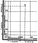
On all sides, the frame has scales divided into minutes. For both latitude and longitude. Moreover, each minute is divided by dots into 6 equal sections, which correspond to 10 seconds of longitude or latitude.
Thus, in order to determine the latitude of any point M on the map, it is necessary to draw a line through this point parallel to the lower or upper frame of the map, and read the corresponding degrees, minutes, seconds on the latitude scale to the right or left. In our example, point M has a latitude of 45°31’30”.
Similarly, drawing a vertical line through the point M parallel to the lateral (closest to this point) meridian of the border of this sheet of the map, we read the longitude (east) equal to 43 ° 31'18 ".
Drawing a point on a topographic map according to given geographical coordinates.
Drawing a point on the map according to the given geographical coordinates is carried out in the reverse order. First, the indicated geographical coordinates are found on the scales, and then parallel and perpendicular lines are drawn through them. Intersecting them on will show the point with the given geographic coordinates.
Based on the book "The map and the compass are my friends."
Klimenko A.I.
When getting into an emergency, a person must first of all be able to navigate the terrain. Sometimes it is necessary to determine the geographical coordinates of your location, for example, to transfer to the rescue service or for other purposes. There are several handy ways to do this. But first, some theory:
The equator divides the globe into northern and southern hemispheres. There are also parallels and meridians. Parallels are circles parallel to the equator. Meridians are circles perpendicular to the equator. The prime meridian passes through the Greenwich Observatory in London. The system of parallels and meridians is a coordinate grid that is used to determine the location and target designation.
Geographic coordinates are made up of latitude and longitude, which are angular quantities that can be used to determine the position of a point anywhere on the globe.
Geographic longitude - the angle measured from the prime meridian, from 0° to 180°. If the account is kept west of Greenwich, then this will be the western longitude, if east, then the eastern. Longitude indicates how far a point is to the west or east of the prime meridian.
Geographic latitude, shows how much the point is north or south of the equator, and makes an angle from 0 ° to 90 °, counted from the plane of the equator to one of the poles - north or south. It follows that the latitude is also north and south.

Schematic definition of latitude and longitude
Geographic coordinates are measured in degrees, minutes and seconds. A degree of geographic latitude is 1/180 of a meridian. Average length one degree of latitude corresponds to approximately 111.12 km. The average length of one minute corresponds to 1852 m (10 cables, or 1 nautical mile). The diameter of the Earth (the length of the earth's axis) between the poles is 12713 km.
Determination of geographic longitude
A degree of longitude is 1/360 of the equator. Since the globe makes a full rotation on its axis in 24 hours, then in 1 hour of time the Earth passes 15 ° of longitude. Respectively:
1° longitude = 4 min. time
1´ = 4 sec time
1" = 1/15 sec time
Based on the above, there is a way to determine the geographic longitude of your location using a watch. To do this, you must have a clock whose time is set at a place with a known longitude and note their readings at local noon, and convert the difference of this time into a degree measure:

Definition of local noon
1). Recalculate your watch to GMT, taking into account the zone corrections (the place in which they are set, if not GMT), daylight savings time and daylight savings.
2). Find noon in the area. To do this, you need to use the gnomon - the oldest sundial, i.e. stuck strictly vertically into the ground with a stick 1-1.5 m. And mark the length of the falling line by marking on the ground. As the sun approaches the zenith, the shadow will begin to shorten, and at the moment when it becomes the shortest, this will be the true solar time at noon in this area, i.e. your sundial shows 12 hours. I would like to note that at noon the shadow of the stick will be directed strictly from south to north.
3). Record your watch - this will be Greenwich Mean Time. Further, the correction from the table should be subtracted from this time, taking into account the sign, since the angular velocity of movement is not constant and depends on the time of year, thereby bringing the mean Greenwich time to true solar.
And now calculate the difference between the true solar time at noon, i.e. 12h and the resulting GMT time, taking into account the correction. The result obtained is converted into a degree measure, this will be the geographic longitude of the area.
Example: the date is May 2, your watch is set to Moscow time. Moscow summer time differs from the world summer by 4 hours. At local noon, the clock showed 18 hours 36 minutes. Hence the Greenwich Mean Time at that moment was 14 hours 36 minutes. We make an amendment + 3 min on May 2. Subtract 12 hours from this, we get 2 hours 36 minutes. taking into account the amendment for May 2, we add 3 minutes and translate into an angular measure. And we get 39 ° west longitude, because local noon came later than GMT.
14:36 + 3min = 14:39 - true solar time
14:39 - 12h = 2:39 = 39° west longitude

Table 1 - Add the correction (with its own sign) to the clock readings to obtain true solar time
The second way is to bring the true solar time at noon to the average, adding to it the correction from table 2, i.e. add the correction to 12h, taking into account the sign 
Table 2 - Bringing the true solar time to the average
Example: The date is October 7th. You have determined solar noon, i.e. 12h. Your clock is set to GMT and shows 8:20. True solar time must be converted to the mean, since the GMT clock also shows the mean. This means that the correction for October 7 is -12 min. (table 2)
12h - 12min = 11:48 am - local mean time 11:48 - 8:20 am = 3:28 am = 55° east longitude because local noon is earlier than Greenwich Mean Time
In fact, tables 1 and 2 differ only in signs. For example, on May 14, from table 1, the correction will be + 3 min, and from the second - 3 min. Therefore, you can use, for example, Table 1 and bring the average time to true solar, and if you bring true solar to the average, then take the opposite sign of the correction. In my opinion, it is more convenient to use the first method, then you will always correct for Greenwich Mean Time and calculate the difference from 12h (true noon)
Or even easier - first calculate the difference between the true solar and mean Greenwich time, and correct the result taking into account the sign from table 2.
Remember, if at the time of local noon GMT is less than 12 hours, then you have east longitude, if more than 12 noon, then west. This method allows you to determine longitude with an accuracy of 2-3 °, and being in extreme situations, you most likely will not have a time equation table at hand to correct for the season, so only due to this the result will differ from the true one by 0 ° - 4°, depending on the season.
Definition of geographic latitude
Latitude can be determined in several ways.
Method number 1. With the help of a protractor and a plumb line. A protractor can be made from two rectangular strips fastened in a compass so that you can change the angle between them.
1). In the center of the protractor, fasten the thread with a load that plays the role of a plumb line.
2). Point the base of the protractor at the polar star.
3). Subtract 90° from the angle between the base of the protractor and the plumb line. The result will be the angle between the pole star and the horizon. Since the polar star has an angular deviation from the axis of the pole of the world by only 1 °, the angle between the polar star and the horizon will be the latitude of the area in which you are located.

Method number 2.
1). Record the length of the day between sunrise on the horizon and full sunset.
2). In the nomogram for determining the latitude, put the received length of the day on the left side, and the date on the right side. Connecting the obtained values with a straight line, determine where it intersects with the middle part. This intersection will be the latitude of your area.

Nomogram for determining geographic latitude